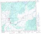
Maps showing Smoking Tent, 2-45-1-W2, Saskatchewan
Smoking Tent is a Unincorporated area located in 2-45-1-W2, Saskatchewan and has an elevation of 335 meters.
- Latitude: 52° 51' North (decimal: 52.8500214)
- Longitude: 102° 3' West (decimal: -102.0504757)
- Topography Feature Category: Unincorporated area
- Geographical Feature: Locality
- Canadian Province/Territory: Saskatchewan
- Elevation: 335 meters
- Location: 2-45-1-W2
- Atlas of Canada Locator Map: Smoking Tent
- GPS Coordinate Locator Map: Smoking Tent Lat/Long
Smoking Tent NTS Map Sheets