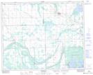
Maps showing Steen, 4-43-11-W2, Saskatchewan
Steen is a Unincorporated area located in 4-43-11-W2, Saskatchewan and has an elevation of 500 meters.
- Latitude: 52° 41' North (decimal: 52.6833347)
- Longitude: 103° 32' West (decimal: -103.5338155)
- Topography Feature Category: Unincorporated area
- Geographical Feature: Hamlet
- Canadian Province/Territory: Saskatchewan
- Elevation: 500 meters
- Location: 4-43-11-W2
- Atlas of Canada Locator Map: Steen
- GPS Coordinate Locator Map: Steen Lat/Long
Steen NTS Map Sheets