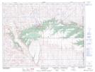
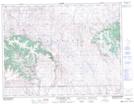
Maps showing Nine Mile Creek, 36-7-30-W3, Saskatchewan
Nine Mile Creek is a River located in 36-7-30-W3, Saskatchewan and has an elevation of 1292 meters.
- Latitude: 49° 36' North (decimal: 49.6000343)
- Longitude: 109° 57' West (decimal: -109.9507652)
- Topography Feature Category: River
- Geographical Feature: Creek
- Canadian Province/Territory: Saskatchewan
- Elevation: 1292 meters
- Location: 36-7-30-W3
- Atlas of Canada Locator Map: Nine Mile Creek
- GPS Coordinate Locator Map: Nine Mile Creek Lat/Long
Nine Mile Creek NTS Map Sheets