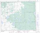
Maps showing Round Lake Recreation Site, 18-39-10-W2, Saskatchewan
Round Lake Recreation Site is a Conservation area located in 18-39-10-W2, Saskatchewan and has an elevation of 594 meters.
- Latitude: 52° 21' 34'' North (decimal: 52.3593936)
- Longitude: 103° 23' 34'' West (decimal: -103.3926453)
- Topography Feature Category: Conservation area
- Geographical Feature: Recreation Site
- Canadian Province/Territory: Saskatchewan
- Elevation: 594 meters
- Location: 18-39-10-W2
- Atlas of Canada Locator Map: Round Lake Recreation Site
- GPS Coordinate Locator Map: Round Lake Recreation Site Lat/Long
Round Lake Recreation Site NTS Map Sheets