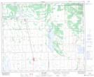
Maps showing Yellowquill 90, 38,39,40-12-W2, Saskatchewan
Yellowquill 90 is a Indian Reserve located in 38,39,40-12-W2, Saskatchewan.
- Latitude: 52° 21' 39'' North (decimal: 52.3606992)
- Longitude: 103° 39' 28'' West (decimal: -103.6579145)
- Topography Feature Category: Indian Reserve
- Geographical Feature: Indian Reserve - Réserve indienne
- Canadian Province/Territory: Saskatchewan
- Location: 38,39,40-12-W2
- Atlas of Canada Locator Map: Yellowquill 90
- GPS Coordinate Locator Map: Yellowquill 90 Lat/Long
Yellowquill 90 NTS Map Sheets