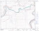
Maps showing Municipal District of Acadia No. 34, 24-2-W4, Alberta
Municipal District of Acadia No. 34 is a Major municipal/district area - major agglomeration located in 24-2-W4, Alberta.
- Latitude: 51° 4' 55'' North (decimal: 51.0819444)
- Longitude: 110° 12' 56'' West (decimal: -110.2155555)
- Topography Feature Category: Major municipal/district area - major agglomeration
- Geographical Feature: Municipal District
- Canadian Province/Territory: Alberta
- Location: 24-2-W4
- Atlas of Canada Locator Map: Municipal District of Acadia No. 34
- GPS Coordinate Locator Map: Municipal District of Acadia No. 34 Lat/Long
Municipal District of Acadia No. 34 NTS Map Sheets