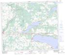
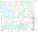
Maps showing Pembina River Provincial Park, 53-7-W5, Alberta
Pembina River Provincial Park is a Conservation area located in 53-7-W5, Alberta and has an elevation of 746 meters.
- Latitude: 53° 36' 28'' North (decimal: 53.6077778)
- Longitude: 114° 59' 50'' West (decimal: -114.9972222)
- Topography Feature Category: Conservation area
- Geographical Feature: Provincial Park
- Canadian Province/Territory: Alberta
- Elevation: 746 meters
- Location: 53-7-W5
- Atlas of Canada Locator Map: Pembina River Provincial Park
- GPS Coordinate Locator Map: Pembina River Provincial Park Lat/Long
Pembina River Provincial Park NTS Map Sheets