Maps showing Lesser Slave Lake, 75-10-W5, Alberta
Lesser Slave Lake is a Lake located in 75-10-W5, Alberta and has an elevation of 564 meters.
- Latitude: 55° 26' 26'' North (decimal: 55.4405555)
- Longitude: 115° 29' 19'' West (decimal: -115.4886111)
- Topography Feature Category: Lake
- Geographical Feature: Lake
- Canadian Province/Territory: Alberta
- Elevation: 564 meters
- Location: 75-10-W5
- Atlas of Canada Locator Map: Lesser Slave Lake
- GPS Coordinate Locator Map: Lesser Slave Lake Lat/Long
Lesser Slave Lake NTS Map Sheets
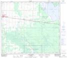
083N08 High Prairie Topographic Map at 1:50,000 scale
083N09 Grouard Topographic Map at 1:50,000 scale
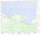
083O05 Driftpile Topographic Map at 1:50,000 scale
083O06 Kinuso Topographic Map at 1:50,000 scale
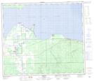
083O07 Slave Lake Topographic Map at 1:50,000 scale
083O10 Marten Lakes Topographic Map at 1:50,000 scale
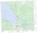
083O11 Narrows Creek Topographic Map at 1:50,000 scale
083O12 Salt Creek Topographic Map at 1:50,000 scale
083N Winagami Topographic Map at 1:250,000 scale
083O Lesser Slave Lake Topographic Map at 1:250,000 scale