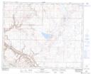
Maps showing Dorothy, 4-27-17-W4, Alberta
Dorothy is a Unincorporated area located in 4-27-17-W4, Alberta and has an elevation of 679 meters.
- Latitude: 51° 16' 45'' North (decimal: 51.2791666)
- Longitude: 112° 19' 30'' West (decimal: -112.3249999)
- Topography Feature Category: Unincorporated area
- Geographical Feature: Locality
- Canadian Province/Territory: Alberta
- Elevation: 679 meters
- Location: 4-27-17-W4
- Atlas of Canada Locator Map: Dorothy
- GPS Coordinate Locator Map: Dorothy Lat/Long