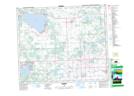
Maps showing Duffield, 26-52-3-W5, Alberta
Duffield is a Unincorporated area located in 26-52-3-W5, Alberta and has an elevation of 726 meters.
- Latitude: 53° 31' 41'' North (decimal: 53.5280555)
- Longitude: 114° 20' 39'' West (decimal: -114.3441666)
- Topography Feature Category: Unincorporated area
- Geographical Feature: Railway Point
- Canadian Province/Territory: Alberta
- Elevation: 726 meters
- Location: 26-52-3-W5
- Atlas of Canada Locator Map: Duffield
- GPS Coordinate Locator Map: Duffield Lat/Long
Duffield NTS Map Sheets