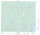
Maps showing Pitlochrie, 35-69-12-W4, Alberta
Pitlochrie is a Unincorporated area located in 35-69-12-W4, Alberta and has an elevation of 589 meters.
- Latitude: 55° 1' 24'' North (decimal: 55.0233333)
- Longitude: 111° 43' 28'' West (decimal: -111.7244444)
- Topography Feature Category: Unincorporated area
- Geographical Feature: Locality
- Canadian Province/Territory: Alberta
- Elevation: 589 meters
- Location: 35-69-12-W4
- Atlas of Canada Locator Map: Pitlochrie
- GPS Coordinate Locator Map: Pitlochrie Lat/Long
Pitlochrie NTS Map Sheets