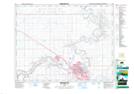
Maps showing Police Point, 32,33-12-5-W4, Alberta
Police Point is a Cape located in 32,33-12-5-W4, Alberta and has an elevation of 656 meters.
- Latitude: 50° 2' 39'' North (decimal: 50.0441666)
- Longitude: 110° 38' 46'' West (decimal: -110.6461110)
- Topography Feature Category: Cape
- Geographical Feature: Point
- Canadian Province/Territory: Alberta
- Elevation: 656 meters
- Location: 32,33-12-5-W4
- Atlas of Canada Locator Map: Police Point
- GPS Coordinate Locator Map: Police Point Lat/Long
Police Point NTS Map Sheets