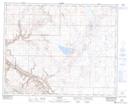
Maps showing East Coulee, 28,29-27-18-W4, Alberta
East Coulee is a Unincorporated area located in 28,29-27-18-W4, Alberta and has an elevation of 702 meters.
- Latitude: 51° 20' North (decimal: 51.3333000)
- Longitude: 112° 29' West (decimal: -112.4832999)
- Topography Feature Category: Unincorporated area
- Geographical Feature: Hamlet
- Canadian Province/Territory: Alberta
- Elevation: 702 meters
- Location: 28,29-27-18-W4
- Atlas of Canada Locator Map: East Coulee
- GPS Coordinate Locator Map: East Coulee Lat/Long