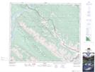
Maps showing Ashlar Ridge, 48-26,27-W5, Alberta
Ashlar Ridge is a Mountain located in 48-26,27-W5, Alberta and has an elevation of 1380 meters.
- Latitude: 53° 10' 22'' North (decimal: 53.1727777)
- Longitude: 117° 48' 18'' West (decimal: -117.8050000)
- Topography Feature Category: Mountain
- Geographical Feature: Ridge
- Canadian Province/Territory: Alberta
- Elevation: 1380 meters
- Location: 48-26,27-W5
- Atlas of Canada Locator Map: Ashlar Ridge
- GPS Coordinate Locator Map: Ashlar Ridge Lat/Long