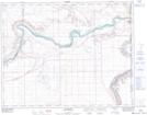
Maps showing Empress Creek, 24-23-1-W4, Alberta
Empress Creek is a River located in 24-23-1-W4, Alberta and has an elevation of 678 meters.
- Latitude: 50° 58' 7'' North (decimal: 50.9686111)
- Longitude: 110° 0' 34'' West (decimal: -110.0094444)
- Topography Feature Category: River
- Geographical Feature: Creek
- Canadian Province/Territory: Alberta
- Elevation: 678 meters
- Location: 24-23-1-W4
- Atlas of Canada Locator Map: Empress Creek
- GPS Coordinate Locator Map: Empress Creek Lat/Long
Empress Creek NTS Map Sheets