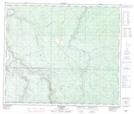
Maps showing Latornell, 12-65-3-W6, Alberta
Latornell is a Unincorporated area located in 12-65-3-W6, Alberta and has an elevation of 846 meters.
- Latitude: 54° 36' 34'' North (decimal: 54.6094444)
- Longitude: 118° 19' 30'' West (decimal: -118.3249999)
- Topography Feature Category: Unincorporated area
- Geographical Feature: Railway Point
- Canadian Province/Territory: Alberta
- Elevation: 846 meters
- Location: 12-65-3-W6
- Atlas of Canada Locator Map: Latornell
- GPS Coordinate Locator Map: Latornell Lat/Long