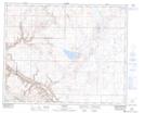
Maps showing Lawsonburg, 29-16-W4, Alberta
Lawsonburg is a Unincorporated area located in 29-16-W4, Alberta and has an elevation of 958 meters.
- Latitude: 51° 29' 1'' North (decimal: 51.4836111)
- Longitude: 112° 9' 33'' West (decimal: -112.1591667)
- Topography Feature Category: Unincorporated area
- Geographical Feature: Locality
- Canadian Province/Territory: Alberta
- Elevation: 958 meters
- Location: 29-16-W4
- Atlas of Canada Locator Map: Lawsonburg
- GPS Coordinate Locator Map: Lawsonburg Lat/Long