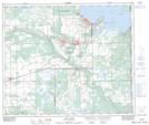
Maps showing Le Goff, 17-62-2-W4, Alberta
Le Goff is a Unincorporated area located in 17-62-2-W4, Alberta.
- Latitude: 54° 22' North (decimal: 54.3666999)
- Longitude: 110° 16' West (decimal: -110.2666999)
- Topography Feature Category: Unincorporated area
- Geographical Feature: Post Office
- Canadian Province/Territory: Alberta
- Location: 17-62-2-W4
- GPS Coordinate Locator Map: Le Goff Lat/Long
Le Goff NTS Map Sheets