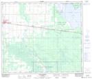
Maps showing Lesser Slave Lake Settlement, 75-14-W5, Alberta
Lesser Slave Lake Settlement is a Geographical area located in 75-14-W5, Alberta and has an elevation of 590 meters.
- Latitude: 55° 31' 10'' North (decimal: 55.5194444)
- Longitude: 116° 7' 31'' West (decimal: -116.1252777)
- Topography Feature Category: Geographical area
- Geographical Feature: Settlement
- Canadian Province/Territory: Alberta
- Elevation: 590 meters
- Location: 75-14-W5
- Atlas of Canada Locator Map: Lesser Slave Lake Settlement
- GPS Coordinate Locator Map: Lesser Slave Lake Settlement Lat/Long
Lesser Slave Lake Settlement NTS Map Sheets