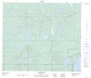
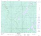
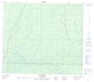
Maps showing Logan River, 71-12-W4, Alberta
Logan River is a River located in 71-12-W4, Alberta and has an elevation of 585 meters.
- Latitude: 55° 9' 17'' North (decimal: 55.1547222)
- Longitude: 111° 42' 30'' West (decimal: -111.7083333)
- Topography Feature Category: River
- Geographical Feature: River
- Canadian Province/Territory: Alberta
- Elevation: 585 meters
- Location: 71-12-W4
- Atlas of Canada Locator Map: Logan River
- GPS Coordinate Locator Map: Logan River Lat/Long
Logan River NTS Map Sheets