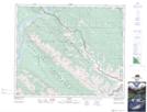
Maps showing Folding Mountain Creek, 48-26-W5, Alberta
Folding Mountain Creek is a River located in 48-26-W5, Alberta and has an elevation of 1809 meters.
- Latitude: 53° 8' 55'' North (decimal: 53.1486111)
- Longitude: 117° 39' 46'' West (decimal: -117.6627778)
- Topography Feature Category: River
- Geographical Feature: Creek
- Canadian Province/Territory: Alberta
- Elevation: 1809 meters
- Location: 48-26-W5
- Atlas of Canada Locator Map: Folding Mountain Creek
- GPS Coordinate Locator Map: Folding Mountain Creek Lat/Long