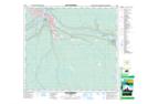
Maps showing The Forks, 89-9-W4, Alberta
The Forks is a River feature located in 89-9-W4, Alberta and has an elevation of 248 meters.
- Latitude: 56° 44' 59'' North (decimal: 56.7497222)
- Longitude: 111° 23' 37'' West (decimal: -111.3936111)
- Topography Feature Category: River feature
- Geographical Feature: Forks
- Canadian Province/Territory: Alberta
- Elevation: 248 meters
- Location: 89-9-W4
- Atlas of Canada Locator Map: The Forks
- GPS Coordinate Locator Map: The Forks Lat/Long
The Forks NTS Map Sheets