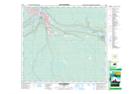
Maps showing Lynton, 8-88-7-W4, Alberta
Lynton is a Unincorporated area located in 8-88-7-W4, Alberta.
- Latitude: 56° 36' 59'' North (decimal: 56.6163888)
- Longitude: 111° 4' 58'' West (decimal: -111.0827777)
- Topography Feature Category: Unincorporated area
- Geographical Feature: Railway Point
- Canadian Province/Territory: Alberta
- Location: 8-88-7-W4
- Atlas of Canada Locator Map: Lynton
- GPS Coordinate Locator Map: Lynton Lat/Long
Lynton NTS Map Sheets