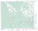
Maps showing Boggy Hall, 34-46-9-W5, Alberta
Boggy Hall is a Unincorporated area located in 34-46-9-W5, Alberta and has an elevation of 810 meters.
- Latitude: 53° 0' 48'' North (decimal: 53.0133333)
- Longitude: 115° 13' 39'' West (decimal: -115.2274999)
- Topography Feature Category: Unincorporated area
- Geographical Feature: Locality
- Canadian Province/Territory: Alberta
- Elevation: 810 meters
- Location: 34-46-9-W5
- Atlas of Canada Locator Map: Boggy Hall
- GPS Coordinate Locator Map: Boggy Hall Lat/Long
Boggy Hall NTS Map Sheets