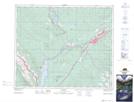
Maps showing Boule Roche, 50-28-W5, Alberta
Boule Roche is a Mountain located in 50-28-W5, Alberta and has an elevation of 2045 meters.
- Latitude: 53° 19' 36'' North (decimal: 53.3266666)
- Longitude: 117° 57' 19'' West (decimal: -117.9552778)
- Topography Feature Category: Mountain
- Geographical Feature: Roche
- Canadian Province/Territory: Alberta
- Elevation: 2045 meters
- Location: 50-28-W5
- Atlas of Canada Locator Map: Boule Roche
- GPS Coordinate Locator Map: Boule Roche Lat/Long