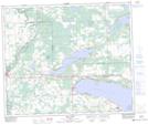
Maps showing Seba Beach, 5,6-53-5-W5, Alberta
Seba Beach is a Village located in 5,6-53-5-W5, Alberta and has an elevation of 743 meters.
- Latitude: 53° 33' 23'' North (decimal: 53.5563888)
- Longitude: 114° 44' 10'' West (decimal: -114.7361110)
- Topography Feature Category: Village
- Geographical Feature: Summer Village
- Canadian Province/Territory: Alberta
- Elevation: 743 meters
- Location: 5,6-53-5-W5
- Atlas of Canada Locator Map: Seba Beach
- GPS Coordinate Locator Map: Seba Beach Lat/Long
Seba Beach NTS Map Sheets