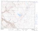
Maps showing McConnell Coulee, 28-18-W4, Alberta
McConnell Coulee is a Valley located in 28-18-W4, Alberta and has an elevation of 794 meters.
- Latitude: 51° 24' 18'' North (decimal: 51.4049999)
- Longitude: 112° 26' 18'' West (decimal: -112.4383332)
- Topography Feature Category: Valley
- Geographical Feature: Coulee
- Canadian Province/Territory: Alberta
- Elevation: 794 meters
- Location: 28-18-W4
- Atlas of Canada Locator Map: McConnell Coulee
- GPS Coordinate Locator Map: McConnell Coulee Lat/Long