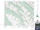
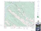
Maps showing Merlin Ridge, 46,47-27-W5, Alberta
Merlin Ridge is a Mountain located in 46,47-27-W5, Alberta and has an elevation of 2142 meters.
- Latitude: 53° 0' 11'' North (decimal: 53.0030555)
- Longitude: 117° 52' 18'' West (decimal: -117.8716667)
- Topography Feature Category: Mountain
- Geographical Feature: Ridge
- Canadian Province/Territory: Alberta
- Elevation: 2142 meters
- Location: 46,47-27-W5
- Atlas of Canada Locator Map: Merlin Ridge
- GPS Coordinate Locator Map: Merlin Ridge Lat/Long
Merlin Ridge NTS Map Sheets