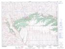
Maps showing Michel Reservoir, 5-7-3-W4, Alberta
Michel Reservoir is a Lake located in 5-7-3-W4, Alberta and has an elevation of 1113 meters.
- Latitude: 49° 31' 51'' North (decimal: 49.5308333)
- Longitude: 110° 22' 17'' West (decimal: -110.3713889)
- Topography Feature Category: Lake
- Geographical Feature: Reservoir
- Canadian Province/Territory: Alberta
- Elevation: 1113 meters
- Location: 5-7-3-W4
- Atlas of Canada Locator Map: Michel Reservoir
- GPS Coordinate Locator Map: Michel Reservoir Lat/Long
Michel Reservoir NTS Map Sheets