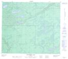
Maps showing Base Lake, 77-12-W4, Alberta
Base Lake is a Lake located in 77-12-W4, Alberta and has an elevation of 660 meters.
- Latitude: 55° 38' 57'' North (decimal: 55.6491667)
- Longitude: 111° 50' 42'' West (decimal: -111.8449999)
- Topography Feature Category: Lake
- Geographical Feature: Lake
- Canadian Province/Territory: Alberta
- Elevation: 660 meters
- Location: 77-12-W4
- Atlas of Canada Locator Map: Base Lake
- GPS Coordinate Locator Map: Base Lake Lat/Long
Base Lake NTS Map Sheets