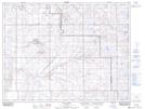
Maps showing Bulls Head, 11-8-7-W4, Alberta
Bulls Head is a Mountain located in 11-8-7-W4, Alberta and has an elevation of 1047 meters.
- Latitude: 49° 37' 42'' North (decimal: 49.6283333)
- Longitude: 110° 50' 34'' West (decimal: -110.8427778)
- Topography Feature Category: Mountain
- Geographical Feature: Butte
- Canadian Province/Territory: Alberta
- Elevation: 1047 meters
- Location: 11-8-7-W4
- Atlas of Canada Locator Map: Bulls Head
- GPS Coordinate Locator Map: Bulls Head Lat/Long
Bulls Head NTS Map Sheets