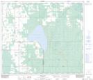
Maps showing Snipe Lake, 70,71-18,19-W5, Alberta
Snipe Lake is a Lake located in 70,71-18,19-W5, Alberta and has an elevation of 746 meters.
- Latitude: 55° 7' 36'' North (decimal: 55.1266666)
- Longitude: 116° 47' 17'' West (decimal: -116.7880556)
- Topography Feature Category: Lake
- Geographical Feature: Lake
- Canadian Province/Territory: Alberta
- Elevation: 746 meters
- Location: 70,71-18,19-W5
- Atlas of Canada Locator Map: Snipe Lake
- GPS Coordinate Locator Map: Snipe Lake Lat/Long
Snipe Lake NTS Map Sheets