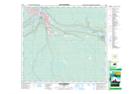
Maps showing The Snye, 89-9-W4, Alberta
The Snye is a Channel located in 89-9-W4, Alberta and has an elevation of 247 meters.
- Latitude: 56° 44' 00'' North (decimal: 56.7333333)
- Longitude: 111° 22' 37'' West (decimal: -111.3769443)
- Topography Feature Category: Channel
- Geographical Feature: Channel
- Canadian Province/Territory: Alberta
- Elevation: 247 meters
- Location: 89-9-W4
- Atlas of Canada Locator Map: The Snye
- GPS Coordinate Locator Map: The Snye Lat/Long
The Snye NTS Map Sheets