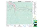
Maps showing Moberly Rapids, 17-89-9-W4, Alberta
Moberly Rapids is a Rapids located in 17-89-9-W4, Alberta.
- Latitude: 56° 43' 9'' North (decimal: 56.7191666)
- Longitude: 111° 24' 30'' West (decimal: -111.4083332)
- Topography Feature Category: Rapids
- Geographical Feature: Rapids
- Canadian Province/Territory: Alberta
- Location: 17-89-9-W4
- Atlas of Canada Locator Map: Moberly Rapids
- GPS Coordinate Locator Map: Moberly Rapids Lat/Long
Moberly Rapids NTS Map Sheets