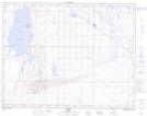
Maps showing Campbell, 24,25,26-17-13-W4, Alberta
Campbell is a Unincorporated area located in 24,25,26-17-13-W4, Alberta.
- Latitude: 50° 27' 33'' North (decimal: 50.4591666)
- Longitude: 111° 40' 30'' West (decimal: -111.6749999)
- Topography Feature Category: Unincorporated area
- Geographical Feature: Railway Point
- Canadian Province/Territory: Alberta
- Location: 24,25,26-17-13-W4
- Atlas of Canada Locator Map: Campbell
- GPS Coordinate Locator Map: Campbell Lat/Long
Campbell NTS Map Sheets