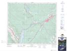
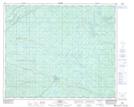
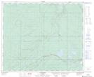
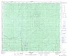
Maps showing Canyon Creek, 23-52-24-W5, Alberta
Canyon Creek is a River located in 23-52-24-W5, Alberta and has an elevation of 1152 meters.
- Latitude: 53° 29' 56'' North (decimal: 53.4988888)
- Longitude: 117° 25' 54'' West (decimal: -117.4316666)
- Topography Feature Category: River
- Geographical Feature: Creek
- Canadian Province/Territory: Alberta
- Elevation: 1152 meters
- Location: 23-52-24-W5
- Atlas of Canada Locator Map: Canyon Creek
- GPS Coordinate Locator Map: Canyon Creek Lat/Long
Canyon Creek NTS Map Sheets