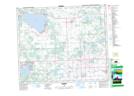
Maps showing Castle Island, 35-54-3-W5, Alberta
Castle Island is a Village located in 35-54-3-W5, Alberta and has an elevation of 719 meters.
- Latitude: 53° 42' 32'' North (decimal: 53.7088888)
- Longitude: 114° 20' 28'' West (decimal: -114.3411111)
- Topography Feature Category: Village
- Geographical Feature: Summer Village
- Canadian Province/Territory: Alberta
- Elevation: 719 meters
- Location: 35-54-3-W5
- Atlas of Canada Locator Map: Castle Island
- GPS Coordinate Locator Map: Castle Island Lat/Long
Castle Island NTS Map Sheets