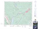
Maps showing Centre Creek, 51-24-W5, Alberta
Centre Creek is a River located in 51-24-W5, Alberta and has an elevation of 989 meters.
- Latitude: 53° 26' 36'' North (decimal: 53.4433333)
- Longitude: 117° 31' 19'' West (decimal: -117.5219444)
- Topography Feature Category: River
- Geographical Feature: Creek
- Canadian Province/Territory: Alberta
- Elevation: 989 meters
- Location: 51-24-W5
- Atlas of Canada Locator Map: Centre Creek
- GPS Coordinate Locator Map: Centre Creek Lat/Long