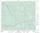
Maps showing Octopus Lake, 52-19-W5, Alberta
Octopus Lake is a Lake located in 52-19-W5, Alberta and has an elevation of 959 meters.
- Latitude: 53° 31' 55'' North (decimal: 53.5319444)
- Longitude: 116° 40' 27'' West (decimal: -116.6741666)
- Topography Feature Category: Lake
- Geographical Feature: Lake
- Canadian Province/Territory: Alberta
- Elevation: 959 meters
- Location: 52-19-W5
- Atlas of Canada Locator Map: Octopus Lake
- GPS Coordinate Locator Map: Octopus Lake Lat/Long