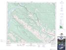
Maps showing Mount O'Hagan, 48-27-W5, Alberta
Mount O'Hagan is a Mountain located in 48-27-W5, Alberta and has an elevation of 2188 meters.
- Latitude: 53° 6' 46'' North (decimal: 53.1127778)
- Longitude: 117° 48' 42'' West (decimal: -117.8116667)
- Topography Feature Category: Mountain
- Geographical Feature: Mount
- Canadian Province/Territory: Alberta
- Elevation: 2188 meters
- Location: 48-27-W5
- Atlas of Canada Locator Map: Mount O'Hagan
- GPS Coordinate Locator Map: Mount O'Hagan Lat/Long