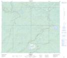
Maps showing Conklin, 31-76-7-W4, Alberta
Conklin is a Unincorporated area located in 31-76-7-W4, Alberta and has an elevation of 562 meters.
- Latitude: 55° 37' 52'' North (decimal: 55.6311110)
- Longitude: 111° 4' 44'' West (decimal: -111.0788889)
- Topography Feature Category: Unincorporated area
- Geographical Feature: Hamlet
- Canadian Province/Territory: Alberta
- Elevation: 562 meters
- Location: 31-76-7-W4
- Atlas of Canada Locator Map: Conklin
- GPS Coordinate Locator Map: Conklin Lat/Long
Conklin NTS Map Sheets