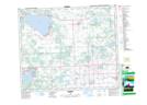
Maps showing Wabamun, 11-53-4-W5, Alberta
Wabamun is a Village located in 11-53-4-W5, Alberta and has an elevation of 733 meters.
- Latitude: 53° 33' 30'' North (decimal: 53.5583333)
- Longitude: 114° 28' 23'' West (decimal: -114.4730556)
- Topography Feature Category: Village
- Geographical Feature: Village
- Canadian Province/Territory: Alberta
- Elevation: 733 meters
- Location: 11-53-4-W5
- Atlas of Canada Locator Map: Wabamun
- GPS Coordinate Locator Map: Wabamun Lat/Long
Wabamun NTS Map Sheets