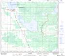
Maps showing Winagami Lake Provincial Park, 76,77-17,18-W5, Alberta
Winagami Lake Provincial Park is a Conservation area located in 76,77-17,18-W5, Alberta and has an elevation of 638 meters.
- Latitude: 55° 38' 36'' North (decimal: 55.6433333)
- Longitude: 116° 40' 47'' West (decimal: -116.6797222)
- Topography Feature Category: Conservation area
- Geographical Feature: Provincial Park
- Canadian Province/Territory: Alberta
- Elevation: 638 meters
- Location: 76,77-17,18-W5
- Atlas of Canada Locator Map: Winagami Lake Provincial Park
- GPS Coordinate Locator Map: Winagami Lake Provincial Park Lat/Long