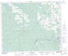
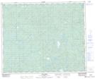
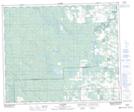
Maps showing Paddy Creek, 11-48-10-W5, Alberta
Paddy Creek is a River located in 11-48-10-W5, Alberta and has an elevation of 938 meters.
- Latitude: 53° 7' 55'' North (decimal: 53.1319444)
- Longitude: 115° 21' 43'' West (decimal: -115.3619443)
- Topography Feature Category: River
- Geographical Feature: Creek
- Canadian Province/Territory: Alberta
- Elevation: 938 meters
- Location: 11-48-10-W5
- Atlas of Canada Locator Map: Paddy Creek
- GPS Coordinate Locator Map: Paddy Creek Lat/Long
Paddy Creek NTS Map Sheets