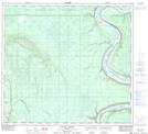
Maps showing Kemp River, 34-98-22-W5, Alberta
Kemp River is a Unincorporated area located in 34-98-22-W5, Alberta and has an elevation of 517 meters.
- Latitude: 57° 32' 39'' North (decimal: 57.5441666)
- Longitude: 117° 29' 41'' West (decimal: -117.4947221)
- Topography Feature Category: Unincorporated area
- Geographical Feature: Locality
- Canadian Province/Territory: Alberta
- Elevation: 517 meters
- Location: 34-98-22-W5
- Atlas of Canada Locator Map: Kemp River
- GPS Coordinate Locator Map: Kemp River Lat/Long
Kemp River NTS Map Sheets