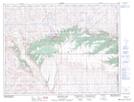
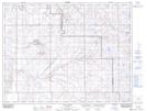
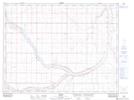
Maps showing Peigan Creek, 4-8-8-W4, Alberta
Peigan Creek is a River located in 4-8-8-W4, Alberta and has an elevation of 819 meters.
- Latitude: 49° 37' 18'' North (decimal: 49.6216667)
- Longitude: 111° 1' 55'' West (decimal: -111.0319444)
- Topography Feature Category: River
- Geographical Feature: Creek
- Canadian Province/Territory: Alberta
- Elevation: 819 meters
- Location: 4-8-8-W4
- Atlas of Canada Locator Map: Peigan Creek
- GPS Coordinate Locator Map: Peigan Creek Lat/Long
Peigan Creek NTS Map Sheets