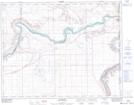
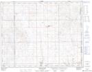
Maps showing Kennedy's Coulee, 29-23-2-W4, Alberta
Kennedy's Coulee is a Valley located in 29-23-2-W4, Alberta and has an elevation of 606 meters.
- Latitude: 50° 57' 4'' North (decimal: 50.9512220)
- Longitude: 110° 13' 10'' West (decimal: -110.2193889)
- Topography Feature Category: Valley
- Geographical Feature: Coulee
- Canadian Province/Territory: Alberta
- Elevation: 606 meters
- Location: 29-23-2-W4
- Atlas of Canada Locator Map: Kennedy's Coulee
- GPS Coordinate Locator Map: Kennedy's Coulee Lat/Long
Kennedy's Coulee NTS Map Sheets