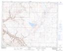
Maps showing Thumb Hill, 10-28-17-W4, Alberta
Thumb Hill is a Mountain located in 10-28-17-W4, Alberta and has an elevation of 950 meters.
- Latitude: 51° 22' 42'' North (decimal: 51.3783333)
- Longitude: 112° 18' 34'' West (decimal: -112.3094444)
- Topography Feature Category: Mountain
- Geographical Feature: Hill
- Canadian Province/Territory: Alberta
- Elevation: 950 meters
- Location: 10-28-17-W4
- Atlas of Canada Locator Map: Thumb Hill
- GPS Coordinate Locator Map: Thumb Hill Lat/Long