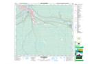
Maps showing Fort McMurray Oil Sands Interpretive Centre Provincial Historic Site (Developed), Alberta
Fort McMurray Oil Sands Interpretive Centre Provincial Historic Site (Developed) is a Conservation area located in Alberta.
- Latitude: 56° 44' North (decimal: 56.7332999)
- Longitude: 111° 23' West (decimal: -111.3832999)
- Topography Feature Category: Conservation area
- Geographical Feature: Provincial Historic Site
- Canadian Province/Territory: Alberta
- Atlas of Canada Locator Map: Fort McMurray Oil Sands Interpretive Centre Provincial Historic Site (Developed)
- GPS Coordinate Locator Map: Fort McMurray Oil Sands Interpretive Centre Provincial Historic Site (Developed) Lat/Long
Fort McMurray Oil Sands Interpretive Centre Provincial Historic Site (Developed) NTS Map Sheets