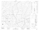
Maps showing Little Horse Creek, 18-84-11-W4, Alberta
Little Horse Creek is a River located in 18-84-11-W4, Alberta.
- Latitude: 56° 34' 37'' North (decimal: 56.5769439)
- Longitude: 111° 34' 31'' West (decimal: -111.5752779)
- Topography Feature Category: River
- Geographical Feature: Creek
- Canadian Province/Territory: Alberta
- Location: 18-84-11-W4
- Atlas of Canada Locator Map: Little Horse Creek
- GPS Coordinate Locator Map: Little Horse Creek Lat/Long
Little Horse Creek NTS Map Sheets